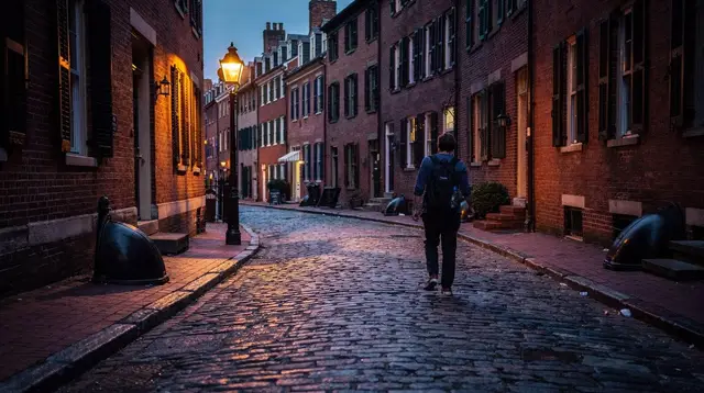
The North End: a Boston neighborhood beyond the restaurants
What is the North End of Boston, beyond its restaurants?
The North End is Boston's oldest residential neighborhood, settled by successive waves of immigrants and Italian since the early twentieth century. It holds Revolutionary-era sites including the Old North Church, narrow colonial-era streets, small parks, and a dense residential community that still lives there year-round.
A neighborhood, not a menu
Most visitors hear about the North End through its food, and the reputation is earned. But treating the North End only as a place to eat cannon overlooks what makes it worth walking slowly: it is Boston’s oldest residential neighborhood, a place where people have lived, worshipped, and raised families continuously since the 17th century. The North End’s food scene has its own dedicated write-up in the Italian food tour guide; this page is about the neighborhood itself — its history, its churches, its geography, and its texture as a place people still call home.
The North End sits on a small peninsula northeast of downtown, bounded by Boston Harbor on one side and the Rose Kennedy Greenway on the other, which replaced the elevated highway that once cut the neighborhood off from the rest of the city. That separation, imposed and then removed, is part of the North End’s story: for decades the elevated Central Artery ran directly overhead, and its removal in the early 2000s reopened easy walking access from downtown.
Layers of immigration
Before it was known as an Italian neighborhood, the North End had already passed through several immigrant communities. English colonists settled it first in the 1630s. Irish immigrants arrived in large numbers in the 19th century, followed by Eastern European Jewish immigrants later in the century. Italian immigration, mostly from southern Italy and Sicily, began in earnest in the 1860s and became dominant by the early 20th century, eventually making the North End one of the most concentrated Italian-American neighborhoods in the country.
That layered history still shows if you know where to look: street names, parish records, and the occasional building cornice tell a story older than the red-sauce restaurants that now dominate the ground floors. The neighborhood’s identity as “Boston’s Little Italy” is real and lived-in, not a themed district — but it is one chapter in a longer sequence of arrivals, not the whole story.
Streets built before cars
Part of what makes the North End feel distinct from the rest of Boston is its street plan. The lanes were laid out in the colonial era, long before anyone planned for automobile traffic, and they were never widened. The result is a grid that isn’t a grid at all: narrow streets that bend, intersect at odd angles, and occasionally dead-end without warning. Hanover Street runs as the neighborhood’s main commercial spine, but the smaller side streets — quieter, mostly residential — are where the North End’s village character comes through most clearly.
Walking these streets works better without a fixed plan. Courtyards open unexpectedly between buildings. Small parks, including the tucked-away Paul Revere Mall (locally called the Prado) behind the Old North Church, offer a moment of quiet a few steps from a busy corner. For a structured route through this kind of terrain, the general Boston walking tour guide covers pacing and footwear advice that applies well here.
The Old North Church and Paul Revere
The single most visited historic site in the North End is the Old North Church, Boston’s oldest surviving church building, completed in 1723. It earned its place in American history on the night of April 18, 1775, when two lanterns were hung in its steeple to signal that British troops were crossing the Charles River by boat rather than marching out by land — the origin of “one if by land, two if by sea,” and the signal that sent Paul Revere on his ride toward Lexington and Concord.
The church is one of the 16 sites connected by the Freedom Trail, the roughly 2.5-mile (4-kilometer) route marked by a painted or brick red line on the sidewalk that runs from Boston Common to Bunker Hill in Charlestown. Following the line itself costs nothing, but the Old North Church, like several other stops along the trail, sells its own ticket for entry to the sanctuary and crypt — a separate transaction from simply walking past it. Full detail on what is free versus ticketed at each of the 16 sites is in the Freedom Trail guide; a fuller account of Paul Revere’s role and the church’s Revolutionary-era history is in the dedicated Old North Church and Paul Revere guide.
A short walk from the church, along the same stretch of the trail, sits Paul Revere’s actual home — one of the oldest buildings in downtown Boston — along with other Freedom Trail stops like Faneuil Hall and the Granary Burying Ground, which lie just outside the North End’s southern edge on the way toward downtown.
Continuity with the Freedom Trail and the harbor
The North End’s geography does a lot of the work of connecting Boston’s Revolutionary history into one walkable arc. Coming from downtown, the Freedom Trail enters the North End near the Paul Revere House and continues past the Old North Church before crossing the bridge toward the Charlestown Navy Yard and Bunker Hill, where the USS Constitution is docked. That means a visitor who starts at Boston Common can walk continuously through downtown, into the North End, and out to the harbor without a transit connection — one of the reasons the neighborhood functions as a hinge point in most people’s first visit to Boston.
That proximity to Boston Harbor also shapes the North End’s daily rhythm. Fishing families and dockworkers were part of the neighborhood’s population for generations, and the harbor’s edge — now largely converted to parkland and waterfront walkways — remains a five-minute walk from the neighborhood’s core streets. It’s a useful detour on a hot day, with harbor breezes doing what the narrow interior streets can’t.
Getting there: Haymarket, not a car
The most direct way into the North End by public transit is the Haymarket station on the T, served by both the Orange Line and the Green Line. From Haymarket, it’s a short walk — a few minutes — across the Greenway and into the neighborhood’s southern edge near Hanover Street. This is by far the simplest approach for most visitors, since parking in the North End is scarce, expensive, and largely reserved for residents.
Walking in from downtown is equally practical: the North End sits close enough to the Freedom Trail’s downtown stops, Faneuil Hall, and the Beacon Hill area that most visitors simply walk over rather than take transit for such a short distance. Coming from Charlestown after visiting the Navy Yard, the pedestrian bridge back into the North End keeps the whole loop car-free.
A crowded neighborhood, especially in summer
The North End is compact — a few hundred acres — and extremely popular, which means its narrow streets can feel genuinely packed on summer evenings. This is especially true during the neighborhood’s traditional feast weekends, when Italian-American religious societies hold outdoor festivals with street processions, live music, and food stalls that close streets to traffic. These feasts run on a rotating schedule through the summer months organized by individual societies, not a single fixed calendar, so exact dates shift from year to year — check locally rather than planning around a specific weekend months in advance.
Outside of feast season, weekday daytime hours are noticeably calmer, and the neighborhood’s residential character is easier to notice: laundry on lines above the street, older residents on folding chairs outside their doors, small grocers doing business the way they have for decades. Early morning, before the day’s visitors arrive, is when the North End looks most like what it actually is — a dense, functioning residential neighborhood rather than a destination.
Walk it with respect
It’s worth stating plainly: the North End is not a themed attraction built for visitors. It is one of Boston’s most densely populated residential neighborhoods, with families living in apartments above nearly every storefront on streets that were never designed for heavy foot traffic. Keeping noise down on quiet side streets, being mindful around building entrances, and not treating stoops or private courtyards as photo backdrops goes a long way toward keeping the neighborhood livable for the people who call it home. The same courtesy applies to any dense historic neighborhood, and it applies here more than most, given how narrow the streets are and how close visitors necessarily walk to people’s front doors.
Beyond the church: other layers worth seeing
While the Old North Church draws the most attention, a few other North End landmarks reward a slower walk. St. Leonard’s Church, established in 1873 as the first Italian Catholic parish in New England, anchors the neighborhood’s religious history distinct from the Anglican Old North Church. The small waterfront parks along Commercial Street give unobstructed harbor views without the crowds of the main tourist stretch. And the neighborhood’s narrow cross streets — Salutation, Sun Court, Garden Court — carry names and layouts that predate the Revolution itself, offering a quieter counterpoint to Hanover Street’s bustle.
For visitors who want to go deeper into the neighborhood’s Italian-American heritage specifically through food and cooking rather than sightseeing, the Italian cooking class guide covers hands-on options that put the neighborhood’s culinary history in context rather than treating it as a backdrop.
Practical notes for a North End visit
| Detail | Note |
|---|---|
| Nearest T stop | Haymarket (Orange Line, Green Line) |
| Walking distance from downtown Freedom Trail stops | About 5-10 minutes |
| Walking distance to Charlestown Navy Yard / USS Constitution | About 10-15 minutes across the bridge |
| Old North Church entry | Ticketed for the sanctuary and crypt; the Freedom Trail line itself is free |
| Busiest period | Summer evenings, especially feast weekends (dates vary by year) |
| Character | Dense, residential, narrow colonial-era streets |
Questions about visiting the North End
Is the North End part of the Freedom Trail?
Yes. Several of the trail’s 16 sites sit inside or at the edge of the North End, including the Old North Church and the Paul Revere House, before the route crosses toward Charlestown.
How do I get to the North End by public transit?
The closest T stop is Haymarket, served by the Orange Line and Green Line. From there it is a short walk under the Rose Kennedy Greenway into the neighborhood.
Is the North End safe to walk at night?
Yes, it is one of Boston’s most walked neighborhoods in the evening, though it is also a dense residential area, so quiet side streets deserve the same everyday caution as any city block.
Do people actually live in the North End?
Yes. It remains one of Boston’s most densely populated residential neighborhoods, with apartments above nearly every storefront, which is part of why it can feel crowded on summer evenings and quiet indoors.
Is the North End within walking distance of Boston Harbor?
Yes. The neighborhood’s eastern edge runs along the waterfront, and the Charlestown Navy Yard and USS Constitution are a short walk across the bridge from its northern tip.
What is the Old North Church known for?
It is the church where two lanterns were hung in April 1775 to signal Paul Revere’s route, the event behind the phrase “one if by land, two if by sea.”
When is the North End most crowded?
Summer evenings, especially during neighborhood feast weekends when streets close to traffic for religious processions and food stalls; exact dates change year to year, so check locally before visiting.
Walking it yourself
A guided walk through the North End that pairs its Revolutionary history with the Freedom Trail’s final downtown stretch is one way to cover the ground efficiently: a small-group walk that links the Freedom Trail’s downtown sites with the North End and the Old North Church. For visitors who want to extend the walk out along the water toward the Seaport, a guided waterfront walk covering Boston’s harbor and seaport history picks up where the North End’s own waterfront edge leaves off.
Either way, the North End rewards unhurried walking more than almost any other Boston neighborhood on this site. Its history isn’t confined to the ticketed sites — it’s in the layout of the streets themselves, in a church that has stood since 1723, and in a community that has occupied this same small peninsula through four centuries of arrivals. See the neighborhood-tours category for more structured ways to explore it, or pair it with a stop in Beacon Hill or Charlestown for a fuller day of Boston’s oldest neighborhoods. For a self-guided version of the Freedom Trail that includes the full North End stretch, see the self-guided walk, and for the destination overview, start at North End or the wider Freedom Trail destination page.
Neighborhood tours of the North End, Beacon Hill and Cambridge on GetYourGuide
Verified deep-linked GetYourGuide tours. Book through these links and we earn a small commission at no cost to you.
GetYourGuide does not provide a product photo for this activity — the image shows the meeting point, photographed by us.