Beacon Hill neighborhood guide
What is Beacon Hill and why do visitors go there?
Beacon Hill is one of Boston's oldest residential neighborhoods, known for brick sidewalks, gas lamps, and the Massachusetts State House. Most visitors walk its streets, browse Charles Street's shops and cafes, and combine it with a stop at Boston Common, reachable via the T's Park Street or Charles/MGH stations.
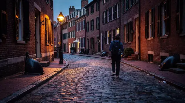
Beacon Hill is the neighborhood most people picture when they imagine old Boston: brick sidewalks, black iron gas lamps, and narrow streets that were laid out long before cars existed. It sits between Boston Common and the Charles River, a few minutes’ walk from downtown but noticeably quieter than it. This guide covers the neighborhood as a whole — its history, its shopping street, its transit access, and how it compares to Boston’s other historic residential district. For a close look at Acorn Street specifically, the single most photographed block on the hill, see the Acorn Street walking guide instead; this page won’t repeat that detail.
One of Boston’s oldest neighborhoods
Beacon Hill takes its name from a beacon that once stood on the highest point of the hill, used to warn colonial Boston of approaching danger. The neighborhood as it looks today largely dates from the late 18th and early 19th centuries, after the Mount Vernon Proprietors — a group that included the architect Charles Bulfinch — began developing the south slope into townhouses for Boston’s merchant class. Bulfinch also designed the Massachusetts State House, completed in 1798, which still anchors the neighborhood’s east side facing Boston Common.
The north slope of the hill had a different history: through the 19th century it was home to a free Black community and a center of Boston’s abolitionist movement, with meeting houses, schools, and residences that now form the Black Heritage Trail. That trail is a separate, marked route through Beacon Hill’s north slope and is worth treating as its own outing rather than a quick detour from Charles Street.
By the later 19th century Beacon Hill had become the settled, affluent residential district it largely remains — federal-style brick rowhouses, purple-tinted “sandwich glass” windows on a handful of Chestnut Street facades, and a street grid that was never widened for modern traffic. Much of the neighborhood is a protected historic district today, which is part of why so little has visibly changed.
For a guided introduction that covers this history in context rather than as a list of dates, a walking tour that pairs Beacon Hill with neighboring Back Bay works well for a first visit — see the walking tour through old Boston that links Beacon Hill and Back Bay, which gives the streets a narrative rather than leaving them as a scenic backdrop.
Charles Street: the neighborhood’s shopping and cafe strip
Charles Street runs along the base of the hill, between Boston Common and the Charles River Esplanade, and is Beacon Hill’s main commercial street. It’s lined with antique dealers, independent boutiques, small galleries, cafes, and restaurants at ground level, with residences above — there’s no mall or chain-retail cluster here, and that’s largely the point. Storefronts turn over, so this guide won’t name a single shop or cafe as the best one; treat Charles Street as a place to browse rather than a checklist.
The street is short enough to walk end to end in about fifteen minutes, though most visitors take longer, stopping in and out of shops. It connects directly to the Charles/MGH T station at its northern end and to the Public Garden and Boston Common at its southern end, which makes it a natural link between a T ride and a walk through the parks.
If wandering without a plan isn’t your style, a small-group or private walking tour focused specifically on Beacon Hill can put Charles Street and the surrounding blocks into a structured route — see a small-group or private walking tour of Beacon Hill’s streets and Charles Street for that option.
The Massachusetts State House and Boston Common
Beacon Hill’s eastern edge borders Boston Common directly, and the Massachusetts State House sits at the top of the Common facing the neighborhood. The State House’s gold dome — originally covered in copper by Paul Revere’s company, later gilded — is one of the most visible landmarks from anywhere on the hill. The building generally offers free tours on weekdays, though hours, security screening, and availability change, so check the State House’s own visitor information before planning around it.
Because the State House sits on the Freedom Trail route, this is the point where Beacon Hill and Boston’s Revolutionary-era walking trail meet — but only at this edge. The rest of Beacon Hill’s residential streets are not marked Freedom Trail stops; they’re a neighborhood to wander separately, before or after following the trail’s red line elsewhere in downtown Boston.
Boston Common itself — the country’s oldest public park, dating to 1634 — and the adjoining Public Garden are both free to enter, any day of the year. They make an easy pairing with a Beacon Hill walk: cross from Charles Street into the Public Garden, then into the Common, then up into Beacon Hill’s streets, all without needing transit in between.
Getting there: Park Street and Charles/MGH
Beacon Hill is served by two MBTA stations on opposite sides of the neighborhood, both described in more detail in the site’s guide to the T:
| Station | Lines | Where it lands you |
|---|---|---|
| Park Street | Red Line, Green Line | East edge, at Boston Common, closest to the State House |
| Charles/MGH | Red Line | West edge, at the river, closest to Charles Street’s north end |
Both stations require a standard T fare, paid with a CharlieCard or contactless payment, with transfers included within a two-hour window — check current fares on mbta.com, since they change periodically. Neither station sits inside Beacon Hill itself; both are a short walk to the neighborhood’s edge, which fits the area’s character as a place built for walking rather than driving. For getting around the wider city without a car, the car-free Boston guide has the fuller picture.
Driving into Beacon Hill is possible but not recommended for a visit: streets are narrow, mostly one-way, and metered or resident-permit parking is limited. If you’re staying elsewhere in the city and want to see Beacon Hill on foot as part of a broader downtown walk, the general guide to walking tours in Boston covers how to sequence it with the Common, the Freedom Trail, and nearby downtown Boston sights.
A quieter counterpoint to downtown
Beacon Hill is almost entirely residential, and it feels that way on the street: low building heights, no major retail chains, and streets that were never built for through traffic. Compared with the Freedom Trail crowds a few blocks away, or the bars and restaurants of the North End, Beacon Hill is noticeably quieter — closer in feel to a small New England town than to a downtown neighborhood.
That quiet is also a reason to be a considerate visitor: these are private homes, not stage sets, and lingering directly in front of doorways or blocking narrow sidewalks for photos is a common source of friction with residents. A short, respectful visit covers the neighborhood well; there’s no need to treat every block the way Acorn Street gets treated.
For visitors curious about the history behind the neighborhood’s quiet streets and its role in the abolitionist movement, a themed walking option covers that angle directly — see a guided history walk through Beacon Hill’s role in the Underground Railroad, which focuses on the north slope’s history rather than the shopfronts of Charles Street.
Snow, spring blooms, and the absence of a real season
Unlike Salem in October or the Common’s Swan Boats in summer, Beacon Hill doesn’t have a defined high season or event calendar. It’s a residential neighborhood, not an attraction with opening dates, and it’s reasonable to visit in any month.
That said, its brick sidewalks, black lamps, and ironwork railings do look particularly good under snow in winter, and some blocks display window boxes and small plantings in spring — both are worth knowing about, though neither is guaranteed or predictable from year to year, and neither should be the sole reason to time a trip. If you’re already planning around New England’s better-known seasonal draws, the site’s fall foliage guide and winter in Boston guide cover those more reliable patterns; Beacon Hill itself is better treated as a year-round stop that happens to photograph well after a snowfall.
Comparing Beacon Hill with Back Bay
Boston has two well-known historic residential districts, and visitors with limited time sometimes ask whether they need to see both. Beacon Hill and Back Bay share some surface similarities — brick facades, tree-lined streets, a 19th-century feel — but they were built differently and read differently on foot.
| Beacon Hill | Back Bay | |
|---|---|---|
| Era | Late 1700s–1800s, organic hillside layout | 1850s onward, built on filled land in a planned grid |
| Street pattern | Narrow, winding, largely pre-automobile | Wide, straight avenues (Commonwealth Avenue, Newbury Street) |
| Architecture | Federal-style brick rowhouses | Victorian brownstones, more ornate facades |
| Commercial strip | Charles Street: small, independent shops | Newbury Street: denser retail, more chain stores |
| Feel | Quiet, residential, village-like | Livelier, more foot traffic, closer to Fenway and the South End |
Neither is objectively better; they’re different enough to justify visiting both if time allows. The full Back Bay brownstones walking guide covers that neighborhood in the same level of detail as this page covers Beacon Hill.
For a broader combination that puts Beacon Hill in context with the Freedom Trail and other downtown sights in one outing, a guided walk covering multiple areas can save separate trips — see a guided walking tour linking the Freedom Trail, Beacon Hill, and Harvard as one option for visitors trying to cover several neighborhoods efficiently.
Visiting Beacon Hill: frequently asked questions
How do I get to Beacon Hill on the T?
The Red Line and Green Line both stop at Park Street, on the east edge of Beacon Hill near Boston Common. The Red Line’s Charles/MGH station sits on the neighborhood’s western edge, closer to the river and the Charles Street shops. Both are a short walk into the neighborhood’s core.
Is Beacon Hill worth visiting if I’ve already walked Acorn Street?
Yes. Acorn Street is one photogenic block; Beacon Hill is a whole neighborhood with more streets, the Charles Street shopping strip, and the Massachusetts State House. A single photo stop on Acorn Street doesn’t cover the area’s history or its everyday shops and cafes.
Is Beacon Hill part of the Freedom Trail?
Beacon Hill borders the Freedom Trail rather than sitting directly on it. The Massachusetts State House, at the top of the Common, is on the official Freedom Trail route; the rest of Beacon Hill’s residential streets are a short detour from it, not stops along the marked line.
What is there to do on Charles Street?
Charles Street is Beacon Hill’s main commercial strip, lined with antique shops, small boutiques, cafes, and restaurants at street level below the residential blocks. It’s a browsing and coffee-stop street rather than a shopping mall, and most storefronts are independent rather than chain retail.
Is Beacon Hill safe and easy to walk at night?
Beacon Hill is a residential, low-traffic neighborhood and is generally considered one of the calmer parts of central Boston to walk after dark, helped by gas lamps on many streets. As anywhere, stick to lit streets and use ordinary city caution.
Can I visit the Massachusetts State House?
The State House sits at the top of Beacon Hill facing Boston Common and is generally open for free guided or self-guided tours on weekdays, though hours and security procedures change, so check the State House’s own site before visiting.
Is Beacon Hill better in a particular season?
Beacon Hill has no strong seasonal draw or festival calendar, unlike Salem in October. Its brick sidewalks and ironwork can look striking after snow or with spring plantings on some blocks, but this varies year to year and isn’t a reason to plan a trip around a specific week.
Neighborhood tours of the North End, Beacon Hill and Cambridge on GetYourGuide
Verified deep-linked GetYourGuide tours. Book through these links and we earn a small commission at no cost to you.
GetYourGuide does not provide a product photo for this activity — the image shows the meeting point, photographed by us.